En
Log in
All resources
Create a design
Tools
38,646 Free Artworks of Map
maps of africa
africa in the 1890s
maps from the earth and its inhabitants, vol. xii
maps from the earth and its inhabitants, vol. xiii
bibliothèque nationale de france
maps from the earth and its inhabitants, vol. xi
maps from the earth and its inhabitants, vol. iv
maps by willem and johannes blaeu
eran laor cartographic collection
paper
maps from the earth and its inhabitants, vol. iv
eddystone rocks, devon
maps from the earth and its inhabitants, vol. iv
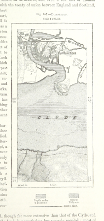
maps of dumbartonshire
maps from the earth and its inhabitants, vol. xvi
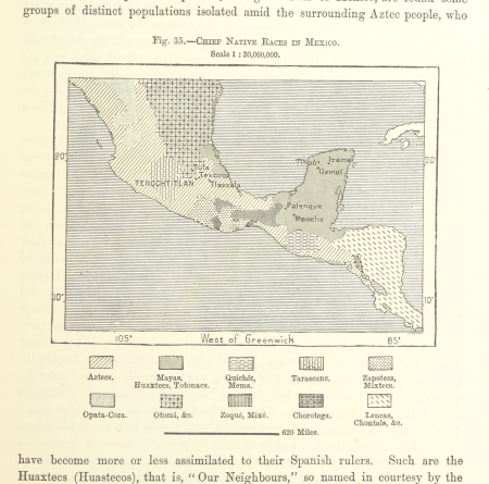
ethnographic maps of north america
maps from the earth and its inhabitants, vol. iv
firth of inverness
maps from the earth and its inhabitants, vol. iv
isle of thanet
mining in south africa
maps of vaal river
maps from the earth and its inhabitants, vol. vi
maps of kerch
maps from the earth and its inhabitants, vol. xvii
1870s maps of florida
maps from the earth and its inhabitants, vol. iv
snaith
maps from the earth and its inhabitants, vol. xvii
linguistic maps of north america
maps of emden by braun & hogenberg
große kirche (emden)
old maps of rovigo
francesco zucchi
maps of the hague by braun & hogenberg
1666 in the hague
old maps of salvador (bahia)
jacob van meurs
maps by willem and johannes blaeu
17th-century maps of bermuda
eran laor cartographic collection
guillaume sanson
drawings by james mcneill whistler in the metropolitan museum of art
aestheticism
geographia universalis (1545) in the british museum
german renaissance,northern renaissance
maps from géographie illustrée de la france et de ses colonies
orientalist painting
old maps of heraklion
baroque
old maps of périgueux
1660s maps of france
maps from the earth and its inhabitants, vol. x
19th-century maps of egypt
gemeente atlas van nederland - zeeland
19th-century maps of zeeland
maps of bamberg by braun & hogenberg
obere pfarre (bamberg)
andrée rexroth
turgot map of paris, kyoto university library – derivative files
couvent des capucines
plan de roussel - derivative files
maps of meudon
maps by willem and johannes blaeu
maps made in the 17th century
maps of alsace by guillaume sanson
1660s maps of alsace
the british monarchy (1743)
maps in the british museum
maps of alsace by guillaume sanson
1660s maps of alsace
maps made in the 17th century
old maps of upper austria
atlas sive cosmographicae (gerardus mercator, 1596)
gerardus mercator
latin-language title pages
girolamo porro
maps from the earth and its inhabitants, vol. xii
africa in the 1890s
maps from the earth and its inhabitants, vol. xiii
africa in the 1890s
maps from the earth and its inhabitants, vol. xi
africa in the 1890s
maps from the earth and its inhabitants, vol. xii
africa in the 1890s
maps from the earth and its inhabitants, vol. xiii
africa in the 1890s
maps from the earth and its inhabitants, vol. xii
africa in the 1890s
maps from the earth and its inhabitants, vol. xi
africa in the 1890s
maps from the earth and its inhabitants, vol. xiii
africa in the 1890s
chicago and the midwest, newberry library
cartographic reliefs
maps from the earth and its inhabitants, vol. xii
africa in the 1890s
maps from the earth and its inhabitants, vol. xii
africa in the 1890s
maps from the earth and its inhabitants, vol. xiii
africa in the 1890s
maps from the earth and its inhabitants, vol. xii
africa in the 1890s
maps from the earth and its inhabitants, vol. x
rosetta branch
maps from the earth and its inhabitants, vol. xi
africa in the 1890s
maps from the earth and its inhabitants, vol. xiii
africa in the 1890s
maps from the earth and its inhabitants, vol. xii
africa in the 1890s
maps from the earth and its inhabitants, vol. xii
africa in the 1890s
maps from the earth and its inhabitants, vol. xii
africa in the 1890s
maps from the earth and its inhabitants, vol. xi
africa in the 1890s
maps from the earth and its inhabitants, vol. xii
africa in the 1890s
maps of brest from bibliothèque nationale de france
lithographs of brest, france
eran laor cartographic collection
william hughes (geographer)
19th-century maps of the black sea
tuzly lagoons national nature park
old maps of the eastern hemisphere
1680s maps of the world
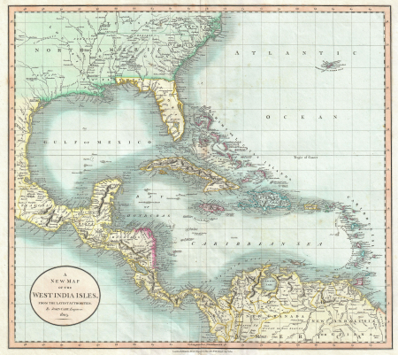
1803 maps of the caribbean
maps by john cary
maps of bernkastel-kues by braun & hogenberg
maps of zell (mosel) by braun & hogenberg
john rocque's 1748 map of london and adjacent country
bibliothèque nationale de france
maps by wilhelm maximilian carpelan
slättens gård, mälarhöjden
cartes de franz schrader
maps of canals in france
merian mainz trier köln
baroque
maps from the earth and its inhabitants, vol. iv
brentford, england
maps from the earth and its inhabitants, vol. iii
mining in austria
eran laor cartographic collection
jacob peeters
bibliothèque nationale de france
maps by tomas lopez
beschreibung der städt der welt - braun & hogenberg - btv1b52512111k
dresden in the 1580s
map of the circle of austria by sanson
1700s maps of austria
demolished churches in de barbari map
ospedale degli incurabili (venice)
demolished churches in de barbari map
san matteo (murano)
maps of liège by johannes blaeu - derivative files
carte de partie de lithuanie (vilnius, troki) by nicolas sanson
cartouches by sanson family
turgot map of paris, kyoto university library
plan de turgot
maps from géographie illustrée de la france et de ses colonies
orientalist painting
amérique méridionale (1748, d'anville)
rococo
crystal palace in hyde park
victorian architecture
description de l'universe
alain manesson mallet
map of paris by jouvin de rochefort (boutier 112)
maps of paris by françois de la pointe
description de l'universe
alain manesson mallet
maps from the earth and its inhabitants, vol. xii
africa in the 1890s
maps from the earth and its inhabitants, vol. xii
africa in the 1890s
maps from the earth and its inhabitants, vol. xii
africa in the 1890s
maps from the earth and its inhabitants, vol. xiii
africa in the 1890s
maps from the earth and its inhabitants, vol. xiii
maps of africa
maps from the earth and its inhabitants, vol. xi
africa in the 1890s
maps from the earth and its inhabitants, vol. xiii
africa in the 1890s
maps from the earth and its inhabitants, vol. xi
africa in the 1890s
maps from the earth and its inhabitants, vol. xi
africa in the 1890s
maps from the earth and its inhabitants, vol. xi
africa in the 1890s
maps from the earth and its inhabitants, vol. xiii
africa in the 1890s
maps from the earth and its inhabitants, vol. xii
africa in the 1890s
maps from the earth and its inhabitants, vol. xii
africa in the 1890s
maps from the earth and its inhabitants, vol. xii
africa in the 1890s
maps from the earth and its inhabitants, vol. xii
africa in the 1890s
maps from the earth and its inhabitants, vol. xiii
africa in the 1890s
maps from the earth and its inhabitants, vol. xi
africa in the 1880s
maps from the earth and its inhabitants, vol. xii
africa in the 1890s
17601 - 17700 of 38,646
Next page
/ 387