En
Log in
All resources
Create a design
Tools
38,646 Free Artworks of Map
eran laor cartographic collection
maps from the earth and its inhabitants, vol. iv
paper
british museum
bibliothèque nationale de france
maps in the library of congress
maps from the earth and its inhabitants, vol. xiii
german renaissance,northern renaissance
geographia universalis (1545) in the british museum
latin-language maps
maps from the earth and its inhabitants, vol. vii
charles eugène perron
maps from the earth and its inhabitants, vol. x
john hanning speke
maps from the earth and its inhabitants, vol. iv
lowestoft
maps from the earth and its inhabitants, vol. vii
19th-century maps of korea
lawrence h. slaughter collection of english maps, charts, globes, books and atlases
de nieuwe en onbekende weereld
maps from the earth and its inhabitants, vol. iv
milford haven
maps from the earth and its inhabitants, vol. iv
rhins of galloway
maps from the earth and its inhabitants, vol. xvii
old maps of washington, d.c.
maps from the earth and its inhabitants, vol. iv
peterborough
rivers of the western cape
maps of the western cape
maps from the earth and its inhabitants, vol. iv
19th-century maps of derbyshire
maps from the earth and its inhabitants, vol. vii
provinces of japan
maps from the earth and its inhabitants, vol. xiv
maps of voyages
1870s maps of venezuela
1878 in venezuela
admiralty charts region b: england wales ireland english channel southern north sea
admiralty charts 1401-1600
geographia universalis (1545) in the british museum
german renaissance,northern renaissance
extra-ptolemaic maps of the americas (1540 design by münster)
german renaissance,northern renaissance
old county maps of hertfordshire
maps by thomas kitchin
geographia universalis (1545) in the british museum
german renaissance,northern renaissance
geographia universalis (1545) in the british museum
german renaissance,northern renaissance
old maps of the northern hemisphere
1800s maps of the world
maps from university of amsterdam special collections
atlas der neederlanden
maps from university of amsterdam special collections
atlas der neederlanden
18th-century maps of western europe
1754 maps of europe
panoramic maps of seville by braun & hogenberg
1635 in andalusia
hôtel de choiseul (rue de richelieu)
salle favart i
maps of emden by braun & hogenberg
1575 in lower saxony
maps in the british museum
jan baptist berterham
pedemontium et monsferratus (galleria delle carte geografiche)
old maps of liguria
russian geographical society
stamps of russia, 2020
eran laor cartographic collection
guillaume sanson
maps in the biblioteca nacional do brasil
1587 maps
eran laor cartographic collection
carolus allard
maps in the library of congress
1755 maps of north america
plan de roussel - derivative files
maps of the bois de boulogne
maps from the earth and its inhabitants, vol. xi
africa in the 1890s
eran laor cartographic collection
latin-language maps
1830s maps of jerusalem
romanticism
1720s maps of slovenia
1725 maps
maps of aalst by braun & hogenberg
coats of arms on maps
maps of aalst by braun & hogenberg
cartouche (cartography)
floor plans of buildings in the london borough of bromley
festival of empire
lawrence h. slaughter collection of english maps, charts, globes, books and atlases
1700 maps of the atlantic ocean
geographia universalis (1545) in the british museum
german renaissance,northern renaissance
lawrence h. slaughter collection of english maps, charts, globes, books and atlases
1700 maps of the atlantic ocean
maps from the earth and its inhabitants, vol. xiii
africa in the 1890s
gemeente atlas van nederland - north holland
old maps of hoorn, north holland
maps of the battle of shiloh
memoirs of henry villard
maps of the french invasion of russia
emery walker
maps from the earth and its inhabitants, vol. xii
people of africa in 2009
17th-century maps of istanbul
baroque
maps by jakob van der schley
history of hormuz island
eran laor cartographic collection
william hughes (geographer)
eran laor cartographic collection
william hughes (geographer)
city gates in gouda
old maps of gouda
eran laor cartographic collection
renaissance
old maps of westphalia
johannes gigas
eran laor cartographic collection
emanuel bowen
maps in the library of congress
plan de roussel
venezuela cum parte australi novae andalusiae - btv1b8596473x
maps by hendrik hondius the younger
eran laor cartographic collection
isaak tirion
media contributed by the frick collection
naïve art
maps in the library of congress
1752 maps of north america
cartouches by sanson family
pierre moullart-sanson
17th-century maps of herefordshire
old county maps of herefordshire
maps by willem and johannes blaeu
old maps of gouda
old maps of whole wales (alone)
1640s maps of wales
maps of goa by linschoten
philippus baldaeus
maps in the library of congress
1877 maps of the united states
maps in the library of congress
1777 maps of north america
old maps of rade de brest
cartes de franz schrader
orbispictus - extracted images
1650s maps of the world
cartes de franz schrader
1894 maps of france
maps in the topographia austriacarum (merian)
baroque
eran laor cartographic collection
william hughes (geographer)
eran laor cartographic collection
cornelis de bruyn
eran laor cartographic collection
cornelis de bruyn
eran laor cartographic collection
william hughes (geographer)
eran laor cartographic collection
joan blaeu
maps from the mechanical curator collection available to georeference
maps from the mechanical curator collection
georg friedrich schmidt
samuel von schmettau
maps in the library of congress
1744 maps
maps from the earth and its inhabitants, vol. xvi
ethnographic maps of north america
maps from the earth and its inhabitants, vol. iv
firth of inverness
maps from the earth and its inhabitants, vol. iv
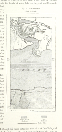
maps of dumbartonshire
maps from the earth and its inhabitants, vol. iv
queensferry crossing
maps from the earth and its inhabitants, vol. vi
topographic maps of asia
maps from the earth and its inhabitants, vol. xiii
19th-century maps of namibia
maps from the earth and its inhabitants, vol. iv
portskewett
maps from the earth and its inhabitants, vol. vii
linguistic maps of chinese languages
maps from the earth and its inhabitants, vol. iii
maps of the sava watercourse system
maps from the earth and its inhabitants, vol. xv
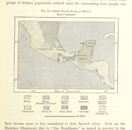
19th-century maps of central america
maps from the earth and its inhabitants, vol. xiii
1878 maps of africa
novi belgii, atlas maior
maps of new england
maps from the earth and its inhabitants, vol. iv
eddystone rocks, devon
mining in south africa
maps of vaal river
maps from the earth and its inhabitants, vol. vi
maps of kerch
maps from the earth and its inhabitants, vol. iv
snaith
maps from the earth and its inhabitants, vol. xvii
linguistic maps of north america
maps from the earth and its inhabitants, vol. xvii
1870s maps of florida
17501 - 17600 of 38,646
Next page
/ 387