En
Log in
All resources
Create a design
Tools
16,754 Free Images of Language
bibliothèque nationale de france
atlas géographique des quatre parties du monde (delisle)
maps of spain by tomas lopez
history
historical
guillaume sanson
united states
maps by willem and johannes blaeu
military
california
maps of spain by tomas lopez
1765 maps of spain
maps of spain by tomas lopez
old maps of navarre
maps of spain by tomas lopez
1765 maps of spain
nature
game
military
army
military
army
17th-century maps of the moluccas
latin-language maps
a history of the town and parish of nantwich, or wich-malbank, in the county palatine of chester (1883)
english-language family trees
prints (print room), leiden university library
dirk eversen lons
illustrations by warwick goble
disrobing of draupadi
gesture
hands
historical
history
historical
history
historical
history
historical
history
historical
history
flagpole
history
historical
history
historical
history
portrait of the artist's son jorge manuel theotokopoulos (el greco)
spanish renaissance,mannerism
japanese prints in the metropolitan museum of art
yokohama-e by utagawa yoshitora
eran laor cartographic collection
claes jansz. visscher (ii)
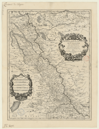
map of the circle of the rhineland by sanson
1730s maps of rhineland-palatinate
1750s maps of central america
maps by tomas lopez
map of the upper rhenian circle by sanson
1690s maps of hesse
eran laor cartographic collection
claes jansz. visscher (ii)
aucuba japonica - botanical illustrations
flora by h. witte (pngs)
maps of the iberian peninsula by guillaume delisle
1700s maps of the iberian peninsula
nicolaes visscher ii
maps from gallica
maps of raucourt
maps of sedan
1762 maps of north america
maps by tomas lopez
bibliothèque nationale de france
prints by ambrogio brambilla
collection des guides joanne. promenades et excursions de gérardmer, 3000 mètres (=om. 060 ; 1 - 50 000 ) - dressé par l. hermann - btv1b84950359
guides joanne
atlas géographique des quatre parties du monde (delisle)
bibliothèque nationale de france
maps by willem and johannes blaeu
17th-century maps of xaintonge
john russell (painter)
old maps of the moon
bibliothèque nationale de france
guillaume sanson
atlas géographique des quatre parties du monde (delisle)
bibliothèque nationale de france
bibliothèque nationale de france
cartouches by tomas lópez
17th-century maps of xaintonge
maps by jodocus hondius ii
atlas géographique des quatre parties du monde (delisle)
bibliothèque nationale de france
liguria, o stato della republica di genova - guiljelmus blaeu - btv1b53165414s
context files from gallica
bibliothèque nationale de france
guillaume sanson
maps from gallica
guides joanne
atlas géographique des quatre parties du monde (delisle)
bibliothèque nationale de france
haute partie de l'evesché de munster subdivisé en ses principales juridictions... - par le sr. sanson - btv1b532024323
guillaume sanson
bibliothèque nationale de france
guillaume sanson
oost-frise, ou le comté d'embden subdivisé en ses principales juridictions - par le sr. sanson - btv1b53202444d
guillaume sanson
maps by pieter mortier
maps from gallica
bibliothèque nationale de france
philippe benoist
bibliothèque nationale de france
guillaume sanson
bibliothèque nationale de france
guillaume sanson
1777 maps of south america
maps by thomas kitchin
john russell (painter)
old maps of the moon
maps of ports and fortresses of the mediterranean by marco boschini (1651)
bibliothèque nationale de france
atlas géographique des quatre parties du monde (delisle)
bibliothèque nationale de france
atlas géographique des quatre parties du monde (delisle)
bibliothèque nationale de france
bibliothèque nationale de france
ambroise tardieu
atlas géographique des quatre parties du monde (delisle)
bibliothèque nationale de france
bibliothèque nationale de france
maps by tomas lopez
bibliothèque nationale de france
cartouches by tomas lópez
carte des régences d'alger by hérisson
bibliothèque nationale de france
carte des pays-bas catholiques by guillaume sanson
robert cordier (engraver)
atlas géographique des quatre parties du monde (delisle)
bibliothèque nationale de france
17th-century maps of transylvania
maps by willem and johannes blaeu
carte de la province de berry (1707) by jaillot
bibliothèque nationale de france
maps by willem and johannes blaeu
old maps of quercy
carte de barbarie, nigritie, guinée par guillaume delisle (1707)
bibliothèque nationale de france
carte de la mer méditerranée en trois feuilles (dheulland et al.)
18th-century maps of the western mediterranean
mapa del principado de cataluña (1776)
cartouches by tomas lópez
mapa del principado de cataluña (1776)
maps of spain by tomas lopez
atlas géographique des quatre parties du monde (delisle)
bibliothèque nationale de france
atlas géographique des quatre parties du monde (delisle)
bibliothèque nationale de france
atlas géographique des quatre parties du monde (delisle)
bibliothèque nationale de france
maps of ports and fortresses of the mediterranean by marco boschini (1651)
bibliothèque nationale de france
maps of ports and fortresses of the mediterranean by marco boschini (1651)
palaiokastro
iceland
maps
juan de la cruz cano y olmedilla
1755 maps of north america
astronomy
maps
french wiktionary icons
self-published work
niversal language selector icons
wmf agora icon set
high renaissance
pirro ligorio
maps of île-de-france by françois de la guillotière
context files from gallica
old maps of curaçao
johannes leupenius
eran laor cartographic collection
isaak tirion
maps of wissembourg by braun & hogenberg
maps of colmar by braun & hogenberg
children
mother
maps by jan eduard wagner
1890s maps of czechia
cartouche (cartography)
jean-claude dezauche
1770s maps of the americas
1775 maps
old maps of the republic of genoa
maps by willem and johannes blaeu
17th-century maps of crete
old maps of candia
landkreis eichsfeld in the 17th century
maps from gallica
military
army
military
ocean
maps of spain by tomas lopez
1766 maps of spain
maps of spain by tomas lopez
old maps of navarre
1780s maps of the americas
1787 maps
maps of spain by tomas lopez
1765 maps of spain
maps of spain by tomas lopez
old maps of navarre
13001 - 13100 of 16,754
Next page
/ 168