En
Log in
All resources
Create a design
Tools
80,426 Free Images of Service
maps from the earth and its inhabitants, vol. iv
nature
usfws
u.s. fish and wildlife service
wyoming
conservation
national wildlife refuge
national wildlife refuge system
seedskadee national wildlife refuge
seedskadee nwr
nature
bird
wildlife
nature
wildlife
nature
wetlands
nature
wildlife
nature
wildlife
nature
wyoming
nature
wildlife
nature
nature
duck
wildlife
nature
wetlands
nature
wildlife
nature
wildlife
nature
wildlife
nature
maps from the earth and its inhabitants, vol. iv
19th-century maps of lincolnshire
civil war echoes, character sketches and state secrets (1907)
edwin d. morgan
det gamle throndhjem (1897)
old maps of trondheim
maps from the earth and its inhabitants, vol. iv
1880s maps of the british isles
a smaller history of greece, from the earliest times to the roman conquest (1897)
maps of the battle of plataea
det gamle throndhjem (1897)
old maps of trondheim
maps from the earth and its inhabitants, vol. iv
1880s maps of the british isles
civil war echoes, character sketches and state secrets (1907)
william p. fessenden
george heriot (artist)
george heriot
the topography of rome and its vicinity (1846)
pratica di mare
maps from the earth and its inhabitants, vol. iv
maps of loch lomond
maps from the earth and its inhabitants, vol. iv
19th-century maps of lancashire
columbus and the indian maiden
det gamle throndhjem (1897)
old maps of trondheim
maps from the earth and its inhabitants, vol. iv
old maps of glasgow
maps from the earth and its inhabitants, vol. iv
maps of the firth of clyde
schleswig-holstein meerumschlungen in wort und bild
civil war echoes, character sketches and state secrets (1907)
matthew h. carpenter
maps from the earth and its inhabitants, vol. iv
maps of ben nevis
bruin - the grand bear hunt (1861)
hunting in book illustrations
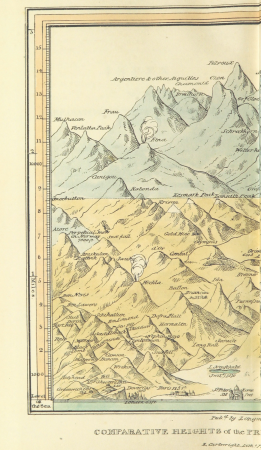
narrative of an ascent to the summit of mont blanc (1830)
mountain height comparison diagrams
civil war echoes, character sketches and state secrets (1907)
schuyler colfax
maps from the earth and its inhabitants, vol. iv
old maps of hartlepool
a smaller history of greece, from the earliest times to the roman conquest (1897)
maps of alexander the great's wars
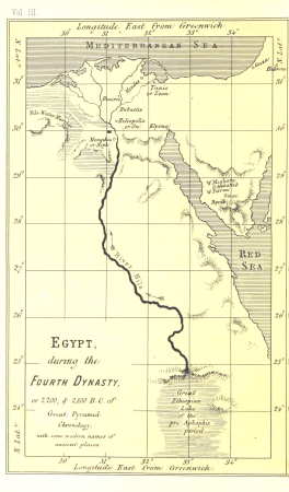
life and work at the great pyramid (1867)
maps of the egyptian old kingdom
cornell's primary geography (1860)
1860 maps of africa
maps from the earth and its inhabitants, vol. iv
old maps of the firth of forth
civil war echoes, character sketches and state secrets (1907)
john a. logan
maps from the earth and its inhabitants, vol. iv
1880s maps of the british isles
civil war echoes, character sketches and state secrets (1907)
roscoe conkling
maps from the earth and its inhabitants, vol. iv
1880s maps of the british isles
historical images of nidelva, trøndelag
det gamle throndhjem (1897)
civil war echoes, character sketches and state secrets (1907)
james warren nye
maps from the earth and its inhabitants, vol. iv
old maps of the hebrides
christopher columbus in art
social realism
maps from the earth and its inhabitants, vol. iv
1880s maps of the british isles
a smaller history of greece, from the earliest times to the roman conquest (1897)
battle of thermopylae
maps from the earth and its inhabitants, vol. iv
1880s maps of the british isles
alexander hamilton u.s. custom house murals
social realism
maps from the earth and its inhabitants, vol. iv
old maps of hadrian's wall
cornell's primary geography (1860)
1860 maps of asia
maps from the earth and its inhabitants, vol. iv
19th-century maps of county durham
schleswig-holstein meerumschlungen in wort und bild
maps from the earth and its inhabitants, vol. iv
1880s maps of the british isles
maps from the earth and its inhabitants, vol. iv
old maps of derby
the journal of american history (1909)
art nouveau
a smaller history of greece, from the earliest times to the roman conquest (1897)
maps of the battle of marathon
maps from the earth and its inhabitants, vol. iv
1880s maps of the british isles
a smaller history of greece, from the earliest times to the roman conquest (1897)
ten thousand campaign
schleswig-holstein meerumschlungen in wort und bild
gustaf brusewitz
a smaller history of greece, from the earliest times to the roman conquest (1897)
maps of troas
изъ исторіи москвы (1896)
sigismund's map of moscow
capua (ship, 1889)
thomas h. willis
a smaller history of greece, from the earliest times to the roman conquest (1897)
old maps of syracuse
maps from the earth and its inhabitants, vol. iv
old maps of leeds
court of neptune fountain
the journal of american history (1909)
art nouveau
maps from the earth and its inhabitants, vol. iv
19th-century maps of lancashire
schleswig-holstein meerumschlungen in wort und bild
civil war echoes, character sketches and state secrets (1907)
benjamin f. wade
a smaller history of greece, from the earliest times to the roman conquest (1897)
old maps of ancient greece
social realism
adriaen block
american civil war in 1861
1861 in maryland
maps from the earth and its inhabitants, vol. xviii
maps of the conquest of peru
military bands of the netherlands
willem constantijn staring
maps from the earth and its inhabitants, vol. xvi
guillaume le testu
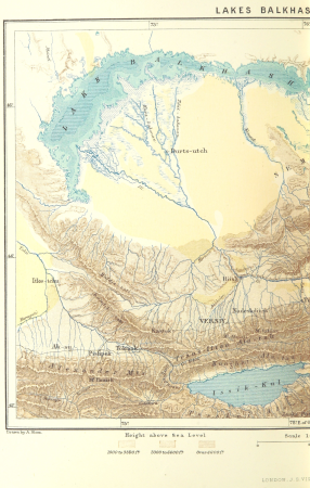
maps from the earth and its inhabitants, vol. vi
old maps of kyrgyzstan
native americans in art
jamestown settlement
maps from the earth and its inhabitants, vol. vi
ferdinand von richthofen
maps from the earth and its inhabitants, vol. vi
old maps of kyrgyzstan
historical
history
maps by macdonald gill
royal mail
frank leslie's scenes and portraits of the civil war (1894)
american civil war in 1862
reconstruction of ruysch's africa map by stanley
en el áfrica tenebrosa (1891)
det gamle throndhjem (1897)
old maps of trondheim
maps from the earth and its inhabitants, vol. iv
19th-century maps of the isle of man
cornell's primary geography (1860)
maps of the po river
meeting the sun - a journey all round the world (1874)
plans of the forbidden city
a smaller history of greece, from the earliest times to the roman conquest (1897)
old maps of ancient athens
maps from the earth and its inhabitants, vol. iv
19th-century maps of kent
maps from the earth and its inhabitants, vol. iv
1880s maps of ireland
schleswig-holstein meerumschlungen in wort und bild
maps from the earth and its inhabitants, vol. iv
1880s maps of the british isles
civil war echoes, character sketches and state secrets (1907)
timothy o. howe
narrative of an ascent to the summit of mont blanc (1830)
mountain height comparison diagrams
30001 - 30100 of 80,426
Next page
/ 805