En
Log in
All resources
Create a design
Tools
80,426 Free Images of Service
history
historical
maps from the earth and its inhabitants, vol. iv
forest
historical photo
forest service pacific northwest region
1880s maps of the british isles
a smaller history of greece, from the earliest times to the roman conquest (1897)
region
six
maps from the earth and its inhabitants, vol. iv
19th-century maps of lancashire
maps from the earth and its inhabitants, vol. iv
1880s maps of the british isles
columbus and the indian maiden
a smaller history of greece, from the earliest times to the roman conquest (1897)
maps of the battle of plataea
det gamle throndhjem (1897)
old maps of trondheim
the topography of rome and its vicinity (1846)
pratica di mare
civil war echoes, character sketches and state secrets (1907)
william p. fessenden
george heriot (artist)
george heriot
maps from the earth and its inhabitants, vol. iv
maps of loch lomond
det gamle throndhjem (1897)
old maps of trondheim
maps from the earth and its inhabitants, vol. iv
1880s maps of the british isles
bruin - the grand bear hunt (1861)
hunting in book illustrations
a smaller history of greece, from the earliest times to the roman conquest (1897)
maps of alexander the great's wars
cornell's primary geography (1860)
1860 maps of africa
maps from the earth and its inhabitants, vol. iv
old maps of the firth of forth
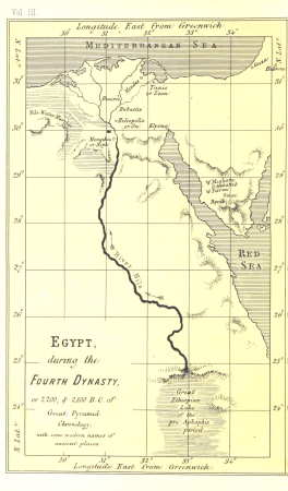
life and work at the great pyramid (1867)
maps of the egyptian old kingdom
maps from the earth and its inhabitants, vol. iv
maps of ben nevis
civil war echoes, character sketches and state secrets (1907)
matthew h. carpenter
maps from the earth and its inhabitants, vol. iv
1880s maps of the british isles
maps from the earth and its inhabitants, vol. vi
population density maps of russia
maps from the earth and its inhabitants, vol. xvii
history of florida
maps from the earth and its inhabitants, vol. xi
old maps of the sahara
the comprehensive history of england (1876)
english-language maps showing history
historical collections of the state of new jersey (1852)
1850s maps of new jersey
maps from the earth and its inhabitants, vol. xv
exploration of the arctic
maps from the earth and its inhabitants, vol. ix
exploration of arabia
frank leslie's scenes and portraits of the civil war (1894)
american civil war in 1861
maps from the earth and its inhabitants, vol. vii
population density maps of china
the comprehensive history of england (1876)
english-language maps showing history
historical
history
maps from the earth and its inhabitants, vol. vi
old maps of kyrgyzstan
maps from the earth and its inhabitants, vol. vi
old maps of kyrgyzstan
american civil war in 1861
1861 in maryland
maps from the earth and its inhabitants, vol. xviii
maps of the conquest of peru
military bands of the netherlands
willem constantijn staring
maps from the earth and its inhabitants, vol. xvi
guillaume le testu
native americans in art
jamestown settlement
maps from the earth and its inhabitants, vol. vi
ferdinand von richthofen
george heriot (artist)
george heriot
travel maps of the united kingdom
australia (1873) by booth
maps from the earth and its inhabitants, vol. iv
old maps of york
civil war echoes, character sketches and state secrets (1907)
timothy o. howe
a smaller history of greece, from the earliest times to the roman conquest (1897)
old maps of ancient athens
maps from the earth and its inhabitants, vol. iv
1880s maps of the british isles
works after map of amsterdam, 1544
george willem hendrik panchaud
alexander hamilton u.s. custom house murals
social realism
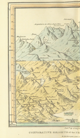
narrative of an ascent to the summit of mont blanc (1830)
mountain height comparison diagrams
bruin - the grand bear hunt (1861)
natural history book covers
maps from the earth and its inhabitants, vol. iv
1880s maps of scotland
maps from the earth and its inhabitants, vol. iv
old maps of liverpool
a smaller history of greece, from the earliest times to the roman conquest (1897)
battle of salamis
bruin - the grand bear hunt (1861)
hunting in book illustrations
civil war echoes, character sketches and state secrets (1907)
james rood doolittle
det gamle throndhjem (1897)
old maps of trondheim
schleswig-holstein meerumschlungen in wort und bild
meeting the sun - a journey all round the world (1874)
plans of the forbidden city
maps from the earth and its inhabitants, vol. iv
19th-century maps of kent
maps from the earth and its inhabitants, vol. iv
1880s maps of ireland
schleswig-holstein meerumschlungen in wort und bild
maps from the earth and its inhabitants, vol. iv
1880s maps of the british isles
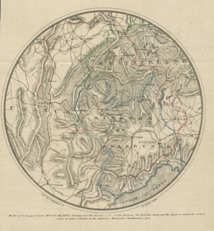
narrative of an ascent to the summit of mont blanc (1830)
maps of massif du mont-blanc
the topography of rome and its vicinity (1846)
tabula peutingeriana places in modern italy
cornell's primary geography (1860)
maps of the po river
det gamle throndhjem (1897)
old maps of trondheim
maps from the earth and its inhabitants, vol. iv
19th-century maps of the isle of man
reconstruction of ruysch's africa map by stanley
en el áfrica tenebrosa (1891)
bruin - the grand bear hunt (1861)
hunting in book illustrations
maps from the earth and its inhabitants, vol. iv
old maps of sheffield
gaspar corte-real
social realism
a smaller history of greece, from the earliest times to the roman conquest (1897)
maps of magna graecia
maps from the earth and its inhabitants, vol. iv
old maps of the isle of arran
the journal of american history (1909)
art nouveau
maps by macdonald gill
royal mail
frank leslie's scenes and portraits of the civil war (1894)
american civil war in 1862
prints by bernard picart in the rijksmuseum amsterdam
bernard picart
service
forest
historical photo
historical
fingerprint
history
historical
history
historical
history
historical
history
historical
history
historical
history
historical
history
historical
history
historical
history
historical
history
artifact
history
history
event
historical
history
historical
history
historical
history
historical
history
historical
history
historical
history
animals
forest
history
forest
forest
tree
history
forest
history
forest
29101 - 29200 of 80,426
Next page
/ 805